


Locus GIS offline land survey
คำอธิบายของLocus GIS offline land survey
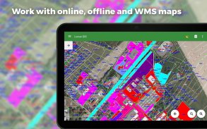
แอปพลิเคชั่น GIS ระดับมืออาชีพสำหรับงานภาคสนามออฟไลน์ด้วย geodata ให้การรวบรวมข้อมูลการดูและการอัปเดต คุณสมบัติทั้งหมดมีอยู่เหนือแผนที่ออนไลน์ออฟไลน์และ WMS ที่มีให้เลือกมากมาย
งานภาคสนาม
•การรวบรวมและอัปเดตข้อมูลภาคสนามแบบออฟไลน์
•จุดประหยัดที่มีตำแหน่งปัจจุบันหรือโดยพลการ
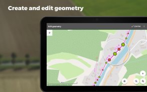
•การสร้างเส้นและรูปหลายเหลี่ยมโดยการบันทึกการเคลื่อนไหว
•การตั้งค่าคุณสมบัติ
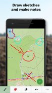
•ภาพถ่ายวิดีโอ / เสียงหรือภาพวาดเป็นไฟล์แนบ
•คำแนะนำจุด
•รวบรวมข้อมูลตำแหน่งสำหรับการบันทึกรูปหลายเหลี่ยม / เส้นหรือคำแนะนำเกี่ยวกับเป้าหมายแม้ว่าแอปจะทำงานอยู่เบื้องหลังก็ตาม
นำเข้า / ส่งออก
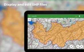
•การนำเข้าและแก้ไขไฟล์ ESRI SHP
•การส่งออกข้อมูลไปยังไฟล์ ESRI SHP หรือ CSV
•ส่งออกโครงการทั้งหมดไปยัง QGIS
แผนที่
•แผนที่ที่หลากหลายทั้งสำหรับการใช้งานออนไลน์และสำหรับการดาวน์โหลด
•รองรับแหล่งที่มาของ WMS
•รองรับแผนที่ออฟไลน์ใน MBTiles, SQLite, MapsForge, TAR, GEMF, รูปแบบ RMAP และข้อมูล OpenStreetMap ที่กำหนดเองหรือธีมแผนที่
เครื่องมือและคุณสมบัติ
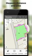
•การวัดระยะทางและพื้นที่
•ค้นหาและกรองข้อมูลในตารางแอตทริบิวต์
•การแก้ไขสไตล์และป้ายข้อความ
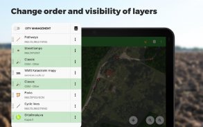
•จัดระเบียบข้อมูลเป็นเลเยอร์และโครงการ
Locus GIS ถูกนำไปใช้อย่างประสบความสำเร็จในหลากหลายอุตสาหกรรม:
•การรวบรวมข้อมูลด้านสิ่งแวดล้อม (การสแกนระบบนิเวศการสำรวจต้นไม้ ... )
•การจัดการและการวางแผนป่าไม้
•การเกษตรและการจัดการดิน
•การกระจายก๊าซและพลังงาน
•การวางแผนและการสร้างฟาร์มกังหันลม
•การสำรวจพื้นที่การขุดและที่ตั้งของบ่อน้ำ
•สำรวจและจัดการสิ่งอำนวยความสะดวกในเมือง
•การก่อสร้างและบำรุงรักษาถนน
Locus GIS offline land survey--เวอร์ชั่น1.23.7
(04-01-2025)Locus GIS offline land survey - ข้อมูล APK
เวอร์ชั่น APK: 1.23.7แพ็คเกจ: menion.android.locus.gisเวอร์ชั่นล่าสุดของLocus GIS offline land survey
เวอร์ชั่นอื่น


แอปในประเภทเดียวกัน


